Antarctica
ANTARCTICA: THE ROSS SEA & THE SUBANTARCTIC ISLANDS

Brown Skuas greeting (Image by Inger Vandyke)

Portrait of a Weddell Seal on ice (Image by Janos Olah)

Southern Elephant Seal flipper detail (Image by Inger Vandyke)

A Southern Fulmar flies past a hole in a gigantic iceberg in Antarctica (Image by Inger Vandyke)

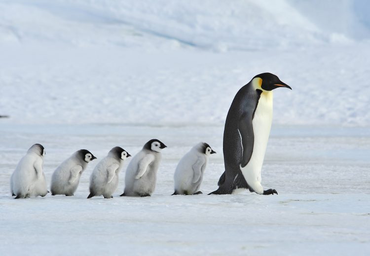
A group of Adelie Penguins in Antarctica (Image by Janos Olah)

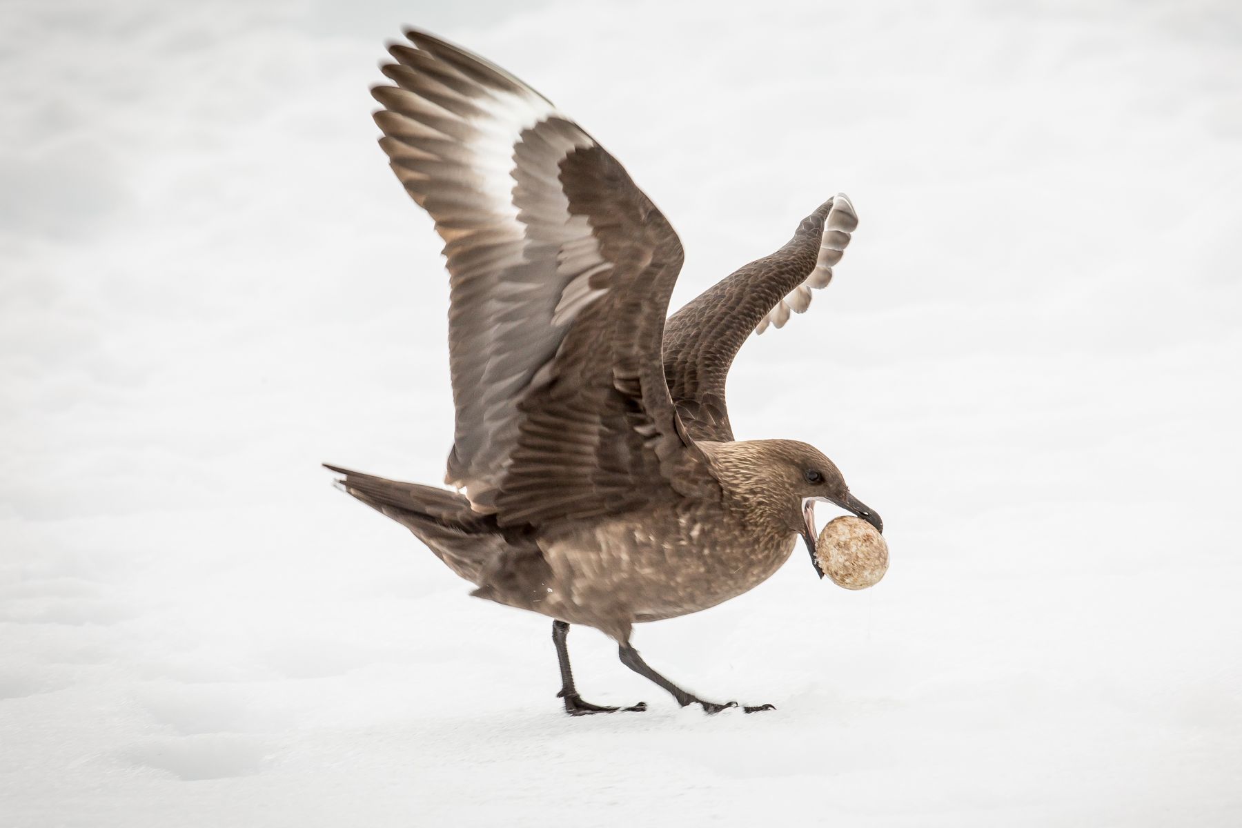
A Brown Skua with his prized Gentoo Penguin egg (Image by Inger Vandyke)

Blue Iceberg (Image by Inger Vandyke)

Sleepy Weddell Seal (Image by Inger Vandyke)

King Penguin colony on South Georgia (Image by Inger Vandyke)

A Southern Giant Petrel devours the carcass of a King Penguin while macabrely two other penguins watch (Image by Inger Vandyke)

King Penguins are photogenic from any angle (Image by Janos Olah)

A dainty Snow Petrel flies through the snow (Image by Janos Olah)

Icebergs (Image by Inger Vandyke)

Snow Petrel (Image by Pete Morris)

King Penguin (Image by Inger Vandyke)

Sleeping King Penguin parents with young on South Georgia (Image by Inger Vandyke)

The flukes of two Southern Humpback whales at sunset in the Lemaire Channel, Antarctica (Image by Inger Vandyke)


Brown Skuas greeting (Image by Inger Vandyke)
Portrait of a Weddell Seal on ice (Image by Janos Olah)
Southern Elephant Seal flipper detail (Image by Inger Vandyke)
A Southern Fulmar flies past a hole in a gigantic iceberg in Antarctica (Image by Inger Vandyke)
A group of Adelie Penguins in Antarctica (Image by Janos Olah)
A Brown Skua with his prized Gentoo Penguin egg (Image by Inger Vandyke)
Blue Iceberg (Image by Inger Vandyke)
Sleepy Weddell Seal (Image by Inger Vandyke)
King Penguin colony on South Georgia (Image by Inger Vandyke)
A Southern Giant Petrel devours the carcass of a King Penguin while macabrely two other penguins watch (Image by Inger Vandyke)
King Penguins are photogenic from any angle (Image by Janos Olah)
A dainty Snow Petrel flies through the snow (Image by Janos Olah)
Icebergs (Image by Inger Vandyke)
Snow Petrel (Image by Pete Morris)
King Penguin (Image by Inger Vandyke)
Sleeping King Penguin parents with young on South Georgia (Image by Inger Vandyke)
The flukes of two Southern Humpback whales at sunset in the Lemaire Channel, Antarctica (Image by Inger Vandyke)
ANTARCTICA (THE ROSS SEA & THE SUBANTARCTIC ISLANDS) WILDLIFE PHOTOGRAPHY TOUR
We are excited to announce our new photo expedition to the Ross Sea and the Subantarctic Islands in January-February 2022. This is one of the most exotic places for a photographer to travel and a rare opportunity, as we venture into what is known as ‘The Heart of Antarctica’. On our way down to Antarctica, we will also visit some of the most remote islands in the world, which hosts a variety of unique wildlife found nowhere else. Our itinerary makes it possible to see as many as 8 different species of penguin, including the Emperor Penguin, and a total of 10-11 different albatross species. As on any expedition, nothing is guaranteed but with 1/3 of the world breeding population of Emperor Penguins found in the Ross Sea region our chances have never been better!
Our partners at WildPhoto have chartered the entire Spirit of Enderby and limited the number of photographers to only 49. Ole J Liodden and Roy Mangersnes will be your hosts for this 30 days (29 nights) long expedition, making sure that our landings and other activities are optimised for photography.
The Spirit of Enderby (Professor Khromov) is a fully ice-strengthened expedition vessel (Russian register KM ice class), which was built in 1984 for polar and oceanographic research and is perfect for photographic expeditions in Antarctica. For those of you who have travelled with us before on Polar Pioneer, these two vessels are sister ships. She was refurbished in May 2019 to provide comfortable accommodation in twin-share cabins, approximately half of which have private bathroom facilities. All cabins have outside windows or portholes and ample storage space. There is a recently updated combined bar/library/lounge area and a dedicated lecture room. The cuisine is excellent and is prepared by top New Zealand and Australian chefs. The ship is crewed by a very enthusiastic and most experienced Russian captain and crew. The name Spirit of Enderby honours the work and the vision of the Enderby Brothers of London. The Enderby Captains were at the forefront of Antarctic exploration for almost 40 years in the early 1800s. It also celebrates Enderby Island, one of the greatest Subantarctic Islands for wildlife in the world.
Our journey takes us from New Zealand via the ‘stepping stones’ of the rugged and wild Subantarctic Islands, including Snares, Auckland, Macquarie and Campbell Islands, breaking our long journey and introducing us to the islands’ rich biodiversity, paving the way to our Antarctic experience. There will be opportunities for thrilling wildlife encounters from nesting albatrosses and rowdy penguin rookeries to lazing seals and sealions. Cetaceans might include Fin, Antarctic Minke, Blue and Humpback Whales; Orca (or Killer Whale) also can be seen in this region. In addition to penguins and albatrosses, we might encounter Snow Petrels, Antarctic Petrels, both Northern and Southern Giant Petrels, Wilson’s Storm Petrel, Cape Petrels and Antarctic Fulmars, whilst Crabeater, Weddell and Leopard Seals may be resting along the ice edge. With long daylight hours and magnificent landscapes, the photographic opportunities are endless in this land of snow and ice.
The Ross Sea was recently protected as the worlds largest marine reserve covering an area of 598,000 square miles (roughly 1,549,000 square kilometres). Ross Sea is sometimes called ‘The Last Ocean’ because it is largely untouched by humans. Its nutrient-rich waters are the most productive in the Antarctic, leading to huge plankton and krill blooms that support vast numbers of fish, seals, penguins, and whales. As one of very few people, you can join us in January 2022 to visit the least altered marine ecosystem on Earth.
As always we will schedule longer stops than usual when going ashore or in zodiacs in order to provide participants with enough time to get excellent pictures. Our main focus is photography and we will do our utmost to make sure you get unique images from one of the most special place on this earth!
SNARES ISLANDS

The Snares, consist of one main island (North East Island) surrounded by several smaller islands and rocks, and a group of islands that are known as the Western Chain. All of The Snares Islands group are bordered by steep cliffs, except for a few eastern parts. The climate is mainly influenced by a warm current coming in from Australia and the mean annual temperature is mild, at 11°C or 52F. Rainfall is about 1200 millimetres or 47 inches per year. The Snares Islands are part of the New Zealand Subantarctic World Heritage Site and are a nature reserve under the Reserves Act of 1977, with landing only by permit. Extreme precautions are taken to prevent non-indigenous plant or animal infestation. Access is only for research purposes, so tourists can only view wildlife by boat.
Wildlife in the Snares Islands includes: Snares Crested Penguin, Buller’s Albatross, Salvin’s Albatross, Sooty Shearwater, Mottled Petrel, Broad-billed Prion, Fairy Prion, Fulmar Prion, Cape Petrel and Brown (Subantarctic) Sku. Other seabirds can also be seen and photographed in the area. Three land birds are endemic to the Snares: the Snares Island Fernbird, the Snares Island Tomtit and the Snares Island Snipe (partly nocturnal). New Zealand Fur Seal breeds on the exposed coasts of the Snares, while an increasing number of New Zealand Sealions come out of the water to rest and warm up on the Snares.
Photographic opportunities: All photography will happen from zodiacs or the ship, since no land-based activities are allowed on the Snares Islands. The seabirds are not afraid and sometimes curious, so there are good photo opportunities from the zodiacs. Albatrosses, petrels and prions are breeding on the islands and can fly close to the zodiacs. The main attraction on the islands is the Snares Crested Penguins, which only breed on these islands. With a population size of about 30,000 individuals, they are not difficult to find on the rocks or in the water. With clear visibility, they can also be photographed with a polecam underwater. NOTE: We need good weather condition to safely navigate with zodiacs along the shoreline and around rocks, but should this visit be cancelled on the way south, we can make a second attempt on the way north towards the end of the expedition.
IMAGES FROM OUR PREVIOUS EXPEDITIONS TO THE SNARES ISLANDS

Snares Islands 2008, Ole J Liodden

Snares Islands 2011, Ole J Liodden
AUCKLAND ISLANDS

The Auckland Islands lie 465 kilometres south of New Zealand’s South Island port of Bluff. They are the largest of New Zealand’s subantarctic islands. As well as having a wide variety of plants and wildlife they also have a rich human history. The Auckland Islands are made up of the remains of two ancient volcanoes which have been subsequently deeply eroded by glaciers. The terrain is rugged and mountainous, with steep cliffs on the western and southern sides and deep valleys with long inlets to the east.
Wildlife in the Auckland Islands includes Yellow-eyed Penguin, Auckland Island Teal, Light-mantled (Sooty) Albatross, Subantarctic Snipe, Auckland Island Shag, Double-banded Plover, Red-crowned Parakeet, Tomtit and Brown Skua. Other birds can also be seen and photographed in the area. New Zealand Sealions can be seen in groups on some of the beaches.
Photographic opportunities: Our main landing will be (if weather allows) at Enderby Island, in the northern part of the archipelago, with a nice beach with Yellow-eyed Penguins and New Zealand Sealions. This is a stronghold for this rare penguin species. The Yellow-eyed Penguins are not breeding in colonies like most other penguins. Inland there are short bushes and trees with birds and some ponds which might attract skuas and other species. On the northern side of Enderby Island, there are cliffs with nesting Light-mantled (Sooty) Albatrosses and Auckland Island Shags.
IMAGES FROM OUR PREVIOUS EXPEDITIONS TO THE AUCKLAND ISLANDS

Auckland Islands 2008, Ole J Liodden

Auckland Islands 2011, Ole J Liodden
CAMPBELL ISLANDS

The Campbell Islands are the southernmost of the New Zealand Subantarctic Islands, located 700 kilometres (435 miles) south of New Zealand’s South Island and 270 kilometres (170 miles) south-east of the Auckland Islands. The 115 square kilometres (44 square miles) main island is shaped somewhat like a giant bird, measuring 16 kilometres (10 miles) east to west and 15 kilometres (9 miles) north to south. It is the highly eroded remnants of an ancient volcano that was last active several million years ago.
Wildlife in Campbell Islands includes, n particular, Southern Royal Albatross, Campbell Albatross, Campbell Island Teal, Campbell Islands Shag, Grey-headed Albatross and Light-mantled (Sooty) Albatross, but other seabirds can be seen and photographed in the area. New Zealand Sealions might be seen and photographed close to the landing in Perseverance Harbour.
Photographic opportunities: Campbell Island is important as a breeding area for the Southern Royal Albatross. We will follow a boardwalk up to the colony area (20-30 minutes walk), enjoying nice views of the nesting area. Some of the area is closed, but there will usually be albatrosses breeding close enough.
IMAGES FROM OUR PREVIOUS EXPEDITIONS TO THE CAMPBELL ISLANDS

Campbell Islands 2008, Ole J Liodden

Campbell Islands 2011, Ole J Liodden
MACQUARIE ISLAND

Macquarie Island, a UNESCO World Heritage Site, lies in the southwest Pacific Ocean, about halfway between New Zealand/Australia and Antarctica. The island is geographically part of ‘Oceania’ and has been politically a part of Tasmania, Australia since 1900. It became a Tasmanian State Reserve in 1978 and was inscribed on the World Heritage List in 1997. Macquarie Island supports one of the highest concentrations of wildlife in the Southern Hemisphere.
Wildlife in Macquarie Island features Royal Penguin, King Penguin, Gentoo Penguin, Southern Rockhopper Penguin and Southern Elephant Seal. Other species can also be seen and photographed in the area.
Photographic opportunities: Macquarie Island is an unique place for a photographer with beaches and surrounding waters crowded by wildlife, mainly birds. The penguins are not shy, and by sitting down on the beach you will soon be surrounded by penguins. Macquarie Islands is on many photographers top-5 lists of places to photograph, and you can see some of the photographic opportunities in the image gallery below.
IMAGE FROM OUR PREVIOUS EXPEDITION TO MACQUARIE ISLAND

Macquarie Island 2011, Ole J Liodden
THE ROSS SEA
The Ross Sea is a deep bay of the Southern Ocean in Antarctica, between Victoria Land and Marie Byrd Land, and is the southernmost sea on Earth. It derives its name from the British explorer James Ross who visited this area in 1841. On our Ross Sea expedition we will explore the western parts of the area.
Wildlife in the Ross Sea includes Emperor Penguin, Adelie Penguin, Antarctic Petrel, Snow Petrel, Crabeater Seal, Weddel Seal, Leopard Seal, Orca (or Killer Whale) and Antarctic Minke Whale. The nutrient-laden water supports an abundance of plankton and this encourages a rich marine fauna. At least ten mammal species, six bird species and 95 fish species are found here, and the sea remains relatively unaffected by human activities.
Photographic opportunities: The photo opportunities in the Ross Sea are very dependent on the weather and ice conditions. We hope for some favourable weather, allowing us to operate the zodiacs for landing in Adelie Penguin colonies, on islands and on the sea ice. We have good chances for observing and photographing Emperor Penguins, but it will not be in (or close) to the colonies, and it is impossible to predict in advance where we can find them on the sea ice. Six Emperor Penguin colonies, including the two biggest, in the area we are exploring are described below.
EMPEROR PENGUIN COLONIES IN THE ROSS SEA:

Cape Roget (71.98°S,170.56°E) is a medium-sized Emperor Penguin colony, with about 7,000 chicks. The colony is located close to the southern tip of Cape Roget. The detailed satellite map in Google Maps reveal this colony (look for the dark penguin poop on the white sea ice).
Coulman Island (73.34°S,169.64°E) is the largest Emperor Penguin colony in Antarctica with about 24,000 chicks each season. The colony is located northwest of Coulman Island, sheltered by an 1100 meter high mountain to the east. The colony can be seen on satellite images in Google Earth. The colony is well studied and you can read more about the penguins’ diving behaviour in this PDF.
Cape Washington (74.65°S,165.38°E) is the second-largest Emperor Penguin colony in the world, with about 23,000 chicks. The colony is located close to the southwestern tip of Cape Washington. The detailed satellite map in Google Maps reveal this colony, and you can even see some of the penguins when zooming in.
Franklin Island (76.18°S,168.40°E) is a small Emperor Penguin colony with about 2000 chicks. See satellite image in Google Maps where you can see the colony and some of the penguins.
Beaufort Island (76.94°S,167.04°E) is a small Emperor Penguin colony in Ross Sea with about 600 chicks. There are no detailed satellite images on Google Maps available for this colony.
Cape Crozet (77.51°S,169.43°E) is a small Emperor Penguin colony in Ross Sea with about 475 chicks, close to the McMurdo Base. This is the most southern Emperor Penguin colony in the Ross Sea and the second most southernly in Antarctica, behind Gould Bay in the Weddel Sea at 77.6°S.
It is important to keep in mind that Emperor Penguins have their colonies on solid sea ice, close to land, and this sea ice never melts during the short summer. These colonies can only be reached by helicopters (or planes), which we do not have on the ship. However the penguins are entering the solid sea ice and walk the last kilometres back to their colonies, and that’s where it is possible to see and photograph Emperor Penguins – at the edge of the sea ice or on ice floes. Single juvenile Emperor Penguins can also be found mixed with Adelie Penguins.
ADELIE PENGUINS IN THE ROSS SEA:
The Adelie Penguin population in the Ross Sea is reported to be the highest in 30 years, with up to a million Adelie Penguin pairs breeding in the Ross Sea region over summer. This population makes up approximately 38 per cent of the entire Antarctic Adelie Penguin population.
The Adelie Penguins breed in many colonies in the western part of Ross Sea. The southernmost Adelie Penguin colonies in the world are located at Ross Island, with Cape Royds (3,500 pairs), Cape Bird (60,000 pairs) and Cap Crozier (150,000 pairs).
OUTLINE ITINERARY
- Day 1: xxxx
To see a larger map, click on the square-like ‘enlarge’ icon in the upper right of the map box.
To see (or hide) the ‘map legend’, click on the icon with an arrow in the upper left of the map box.
To change to a satellite view, which is great for seeing the physical terrain (and for seeing really fine details by repetitive use of the + button), click on the square ‘map view’ icon in the lower left corner of the ‘map legend’.
PRICE INFORMATION
Wild Images Inclusions: Our tour prices include surface transportation, accommodations and meals.
Initial Deposit: US$4500. Our office will let you know what deposit amount is due, in order to confirm your booking, following receipt of your online booking form.
There will be two further interim deposit payments and a final balance payment prior to departure.
Cancellation Charges: The charge is 100% of the payment(s) made up to the date of cancellation.
TO BOOK THIS TOUR: Click here (you will need the tour dates)
2022: For Invercargill/Invercargill arrangements, including one night’s accommodation in Invercargill:
(Not available: Main Deck triple-berth cabin with shared bathroom facilities)
£18140, $24495, €21870 in a Main Deck twin-berth cabin with shared bathroom facilities
£19250, $25995, €23200 in a Superior Cabin with private bathroom
£21470, $28995, €25880 in a Superior Plus Cabin with private bathroom
£22210, $29995, €26780 in a Mini Suite with private bathroom
£24440, $32995, €29450 in an Heritage Suite with private bathroom.
In addition, there will be a charge to cover the landing/visitor fees levied by the local governments of £590, $800, €710 per person.
MAIN DECK – 300 LEVEL

1 MAIN TRIPLE CABIN (blue) with one bunk (one upper and one lower berth) and one additional lower berth, writing desk, wardrobe and drawers. Private washbasin. Nearby shower and toilet facilities are shared with other Main Deck cabins. This cabin has a porthole.
8 Main TWIN CABINS (yellow) with two lower berths, writing desk, wardrobe and drawers. Private washbasin. Nearby shower and toilet facilities are shared with other Main Deck cabins. These cabins have a porthole.
MIDDLE DECK – 400 LEVEL
2 SUPERIOR TWIN CABINS (pink) with one bunk with upper and lower berths, writing desk, wardrobe and drawers. Private bathroom with shower, toilet and washbasin. These cabins have windows.
6 SUPERIOR PLUS TWIN CABINS (green) with two lower berths or a double bed (#411), writing desk, wardrobe and drawers. Private bathroom with shower, toilet and washbasin. These cabins have windows.
UPPER DECK – 500 LEVEL

4 SUPERIOR PLUS TWIN CABINS (green) with two lower berths, writing desk, wardrobe and drawers. Private bathroom with shower, toilet and washbasin. These cabins have windows.
2 MINI SUITES (blue) with a lounge with a single bed or sofa, separate bedroom with a DOUBLE bed, writing desk, wardrobe and drawers. Private bathroom with shower, toilet and washbasin. Mini suites have windows.
1 HERITAGE SUITE (red) with a large lounge area with a single bed and separate bedroom with DOUBLE bed, writing desk, wardrobe and drawers. Private bathroom with shower, toilet and washbasin. Large forward and side facing windows, allowing great views.
Gratuities for the expedition staff and crew, and the taxi transfer to the hotel, are not included in the tour price. Gratuities are entirely at your discretion. The staff work very long hours to make such cruises a success, including a great deal of night sailing, and we have been told that most passengers give gratuities of around US$300-450 for such a cruise.
Single Supplement: Single occupancy of some cabins can be obtained in return for a large supplement on top of the twin-share cruise price for the cabin concerned; this supplement also entitles you to single room accommodation at the pre-cruise hotel. Please enquire to our office.
Please note that if you are willing to share but no cabin-mate is available you will not have to pay the single occupancy supplement.
This tour is priced in US Dollars. Amounts shown in other currencies are indicative.
Air Travel To & From The Tour: Our in-house IATA ticket agency will be pleased to arrange your air travel on request, or you may arrange this yourself if you prefer.
ANTARCTICA: ROSS SEA & SUBANTARCTIC ISLANDS WILDLIFE PHOTOGRAPHY TOUR: DETAILED ITINERARY

Map of our planned itinerary during our Ross Sea and Subantarctic Islands photography tour, but this is very dependent on weather and ice conditions.
Day 1
Invercargill – Arrive at Invercargill, New Zealand’s southernmost city. Meet your fellow expeditioners for an informal get-together over dinner. Hotel night included.
Day 2
Enjoy breakfast at the hotel restaurant and exploring some of the local attractions before heading to the Port of Bluff, where you will board Spirit of Enderby. Settle into your cabin and join your expedition team and the captain for a welcome on board. We set sail for the Snares.
Day 3
Snares Island – If weather allows we will explore with zodiacs, photographing Snares penguins, Buller’s Albatross and other birds nesting on the imposing cliffs.
Days 4-5
Auckland Islands – Characterised by towering cliffs and rugged sea stacks. We visit Enderby Island which is, perhaps, the most beautiful of all the Subantarctic Islands. If weather allows we might also have a chance to explore one of the albatross colonies in the area.
Day 6
At sea – Heading towards Macquarie Island
Days 7-8
Macquarie Island – This remote, rocky outpost which endures roaring westerly winds supports one of the highest concentrations of wildlife in the Southern Hemisphere and might be considered the eastern equivalent to South Georgia.
Days 9-12
At sea – heading towards the Ross Sea.
Days 13-22
Antarctica’s Ross Sea Region – With unpredictable ice and weather conditions, giving a precise day-by-day itinerary is not possible, but we will assess the conditions daily and take every opportunity to make landings and launch the zodiacs to photograph wildlife and great landscapes. We plan to spend as much time as possible in areas maximizing our chances to see the Emperor Penguins.
Days 23-26
At sea – Heading north towards Campbell Island.
Days 27-28
Campbell Island – We drop anchor in Perseverance Harbour, an occasional refuge for Southern Right Whales, which come here to calve. We walk up to the nesting site of the Southern Royal Albatross which is the highlight on this island. We will also plan for other photographic opportunities on or around the island.
Day 29
At sea – Heading back to the port of Bluff.
Day 30
We disembark at Bluff and have a bus transfer back to Invercargill.
Antarctica
November 2024
EMPEROR PENGUINS OF ANTARCTICA: An extraordinary visit to a colony in the Weddell Sea by air
Falkland Islands & South Georgia
November-December 2024